Across the Atlantic, the Mediterranean, the Baltic and the Black Sea, Europe is confronted with a complex environmental challenge: how to protect marine biodiversity at a scale that reflects ecosystem connectivity, cross-border dynamics and the accelerating impacts of climate change.
The Horizon Europe project MPA Europe addresses this challenge through integrated, data-driven analysis and strategic spatial planning.
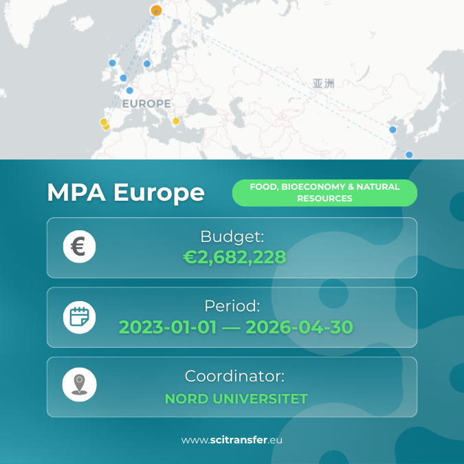
Funded under Horizon Europe (HORIZON-RIA, Topic HORIZON-CL6-2021-BIODIV-01-12), the project runs from 1 January 2023 to 30 April 2026, with a total EU contribution of €2,682,228. Coordinated by Nord universitet, the consortium brings together research and policy institutions, including the Scottish Association for Marine Science, the Joint Nature Conservation Committee, UNESCO, the Ocean University of China, and additional partners across Europe and beyond.
Its objective is to identify the optimal 10% and 30% of European sea areas to prioritise as Marine Protected Areas (MPAs) in support of the EU Biodiversity Strategy for 2030, while maximising potential climate co-benefits.
From Data to Strategic Protection
MPA Europe covers the Atlantic Exclusive Economic Zones (EEZs) of EU Member States and neighbouring countries, as well as the entire Mediterranean, Baltic and Black Seas. This pan-European scope allows marine ecosystems to be analysed as interconnected systems rather than as administratively fragmented jurisdictions.
The project integrates multiple scientific components:
- Species distribution models for thousands of marine species
- High-resolution habitat maps, including biogenic habitats structured by marine flora and fauna
- A data-driven classification of European marine ecosystems based on Copernicus and EMODnet environmental datasets
- Spatial assessments of marine carbon storage (“blue carbon”)
- Connectivity modelling and climate velocity analysis
Rather than relying solely on static biodiversity inventories, this framework enables spatial prioritisation based on:
- Concentrations of species and habitats
- Ecosystem representativity
- Ecological connectivity
- Long-term resilience under projected climate change
Proposed MPA networks are evaluated not only for their current ecological value, but also for their capacity to accommodate future species shifts driven by climate change. In this way, protection strategies are designed to account for dynamic marine systems rather than fixed baseline conditions.
Aligning Marine Protection with EU Climate Policy
Marine Protected Areas have traditionally been viewed primarily as conservation instruments. MPA Europe extends this perspective by systematically examining the relationship between biodiversity indicators and marine carbon storage potential.
By analysing spatial overlaps between biodiversity-rich areas and carbon-dense habitats, the project reinforces the scientific basis for aligning marine conservation with EU climate objectives under the European Green Deal.
This integrated approach supports greater coherence across biodiversity policy, climate mitigation efforts and marine spatial planning frameworks, including the EU Biodiversity Strategy for 2030 and broader decarbonisation targets.
Transparency, Participation and Decision Support
MPA Europe is designed as an open and participatory process.
Feedback from Marine Spatial Planning (MSP) stakeholders across Europe’s regional seas is incorporated into the network design methodology. The project also provides decision-support tools that allow users to explore alternative MPA configurations based on different ecological and policy priorities.
Policymakers, NGOs, researchers and other stakeholders can:
- Examine spatial prioritisation scenarios
- Assess trade-offs between biodiversity and carbon objectives
- Review the analytical basis for area selection
All maps and datasets are made openly available through established European platforms, including EMODnet, the Ocean Biodiversity Information System (OBIS) and the European Commission’s Knowledge Centre for Biodiversity. An online atlas developed within the project further supports transparency, traceability and reproducibility of results.
In a policy context where marine management decisions can be subject to competing interests, this commitment to open data is intended to support scientific credibility and institutional trust.
Delivering Value for Policy, Science and Society
MPA Europe generates structured, policy-relevant outputs across multiple domains:
For policymakers and funding bodies, it provides a scientifically robust, continent-wide spatial evidence base to support implementation of the EU’s 10% strict protection and 30% overall protection targets.
For climate strategy, it advances understanding of the contribution of marine ecosystems to carbon storage, reinforcing the link between biodiversity conservation and climate mitigation policy.
For marine science, the project contributes methodological progress in ecosystem classification, species distribution modelling, connectivity analysis and integrated spatial prioritisation at a pan-European scale.
For marine spatial planners, it delivers operational decision-support tools that translate complex ecological datasets into usable planning scenarios.
For the wider public and research community, it ensures open access to datasets and transparent methodologies, enabling technical outputs to function as shared European knowledge resources.
Strategic Relevance for Europe’s Marine Policy
With €2,682,228 in EU funding over 40 months, MPA Europe delivers policy-relevant outputs across all major European seas. By combining ecological modelling, carbon mapping, stakeholder engagement and open dissemination, the project provides a structured analytical framework to inform future marine protection efforts.
As Europe progresses toward its 2030 biodiversity and climate targets, the key question is not only how much ocean should be protected, but how strategically protection should be designed.
MPA Europe contributes the spatial evidence and methodological tools needed to inform that decision. When the project concludes in April 2026, its openly accessible datasets, prioritisation maps and analytical tools will remain available to support marine policy development in the years ahead.
Autor: Radoslav Todorov
Images: mpa-europe.eu, canva.com
Main Sources
- MPA Europe official website: https://mpa-europe.eu/
- CORDIS project page (Grant ID 101059988): https://cordis.europa.eu/project/id/101059988
- Zenodo MPA Europe community: https://zenodo.org/communities/mpaeurope/about
- MPA Europe LinkedIn page: https://www.linkedin.com/in/mpa-europe-project/
Map SciTransfer EU (https://map.scitransfer.eu/project/mpa-europe-101059988)